Formal repave/rehab of SR4 pathway aka East Coast Greenway from OBC to Salem Church Rd.
Formal repave/rehab of Old Ogletown Rd-SR4 pathway.
Addition of a spur pathway to the gravesite & marker, w/bench and bike parking (inverted U).
DelDOT assessment of Ogletown Baptist Church/Old Red Mill Rd pathway spur for rehab/repave.
Work with OBC toward an easement that will permit Old Red Mill Rd pathway spur for public use.
Designate car parking for site visitation? (if feasible).
Warnock/Connolly:
Region is disenfranchised for open space, pathways, historical recognition, and place-making.
East Coast Greenway is a national project deserving of community connectivity.
OBC/Red Mill pathway is a crucial connection between Prides Crossing and SR4/ECG.
Old Ogletown Rd pathway is a crucial connection from Chestnut Hill Estates to ECG and gravesite.
Will assist legislators if asked, and encourage citizen support as needed.
Upon approval of pathway and access improvements, will redirect advocacy toward DelDOT to ensure that pedestrian and bicyclist’s needs are correctly met.
It was agreed upon that approval of the historical marker is first priority at this time, followed by the above mentioned infra improvements. It was not discussed if any formal announcement or press release should be issued as per the passing of Thomas Ogle on Dec 23, 1771 (250 years) -- or wait until official press release.
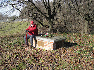
On Dec 23, the date of Thomas Ogle's passing 250 years ago, we visited his gravesite to perform a minor tidy up. During foliage season, the tomb was in danger of disappearing from overgrowth. I was joined by Christopher Thompson George, who removed trash from the site as I pruned back tree branches. Christopher is a published British-born historian of the War of 1812 in the Chesapeake. Among his proudest achievements as an Advocate was helping save the Baltimore County War of 1812 North Point Battlefield of September 12, 1814 from the boot of developers.
As we completed our mission over an unopened bottle of Tott's champagne, I learned that Christopher is 3 years living in Ogletown, and very interested in the local history here after relocating from Maryland. We talked about his above land-use victory in Maryland, and the loss of the Orphanage Property in western Ogletown. It comes with great sadness that no amount of historical significance, environmental imperative or socio-economic needs can overcome Govt corruption in Delaware in matters of land-use.
Orphanage Property in Nov 2016
For the record, saving the Orphanage Property (STOP) was a three year grassroots campaign (2015-2018) to save the last significant open space in Ogletown, Delaware, the Our Lady of Grace 180 acre Orphanage Property, for a regional park. Lost to a deluge of illegal high density development, this was the last chance for the community of Ogletown-S. Newark to fulfill and live the vision promised by Gov Ruth Ann Minner's "Livable Delaware" initiative, or Gov Markell's "Trails and Pathways" or "Walkable Bikeable Delaware" as espoused by Bike Delaware (fraud).
As we continue to mourn the horrific loss above, our effort to add a historical marker and new pathway infrastructure at Thomas Ogle's gravesite will hopefully gain momentum in 2022. This small piece of green space, flanked by highway on and off ramps, is DelDOT-owned and hopefully remains off-limits to developers. Unfortunately, not even the most critical habitat area is truly off-limits in Delaware, and one grave is easy enough to relocate. Even though it is far from ideal for parkland or placemaking given illegal vehicle noise alone, we should still watch and demand protection for this historic plot of land as as the future unfolds.
Thomas Ogle House (photo courtesy of Scott Clabaugh)
For local history enthusiasts, the Wikipedia page for Ogletown has been updated to include a more in-depth look at its history, and to reflect on current events. Formerly a stub, additional edits and additions are always encouraged. You may also include these in comments below.
Thomas Ogle (born 1666-1672, died 1734), son of John Ogle who arrived in Delaware in 1665 from England, was an early colonial landowner in what is today centralNew Castle County Delaware. Ogletown is named after his son Thomas Ogle II (born about 1705, died 1771), who settled in the area of present-dayDelaware Route 273andDelaware Route 4in the 1730s.[2]The burial siteof Thomas Ogle II is isolated within a highway cloverleaf, and is the focus of an effort currently underway to recognize his passing and to revitalize the area. The name is associated with the area from before 1774, and in the late 19th century it was a small village with a store, a post office, and about half a dozen houses.[3]Additional homes and businesses sprang up throughout the 20th century. Ogletown would eventually lose its village-like character to suburban sprawl, road re-alignments, the arrival ofMaryland National Bank(MBNA), and the construction of arterial highways.
Ogletown prospered during the 17th century because of a location along one of the major transpeninsular roads laid out in Delaware, extending from the Head of Elk on the Chesapeake Bay to Christiana Bridge. The dogleg nature of the roads in the Ogletown area created an ideal situation for the creation of a hamlet-type community, including an inn and place of lodging.[4]
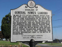
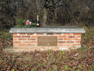
From 1994-1999, a road expansion project of Route 273 obliterated any remnants of the original hamlet. In the course of highway construction, the grave of Thomas Ogle II was uncovered, "badly disturbed by road construction and the construction of a gas station on the site." As part of the project, and with the generous financial support of the Ogle Family Association (O/OFA), DelDOT restored the rectangular brick base and capstone, leaving Thomas' remains untouched, in what is now green space inside the new cloverleaf intersection. Only a small plaque on the brick base commemorates the history of the town.[5][6]
In 2016, a group called Save the Orphanage Property (STOP) began a campaign to preserve Ogletown's last remaining open space suitable for a regional park, located in the town's western flank. The effort was defeated in 2018, with Advocates citing multiple examples of government corruption as the primary cause.
In 2021, Advocates submitted an application with Delaware Public Archives for a historical marker, to begin an effort to recognize Ogletown, given that the town's founder, Thomas Ogle, died in 1771, 250 years ago.
Today, residents and businesses in the area have Newark postal addresses, and the name Ogletown survives primarily in the names of Ogletown Road and Ogletown-Stanton Road. [full page continues HERE]
The following has been submitted with an application for a Historical Marker at the grave site of Thomas Ogle, who will have died 250 years ago as of Dec 23, 2021.
Background:
In 1955, when DelDOT first widened State Road (SR) 4 at Salem Church Road, the Thomas Ogle House stood in the way. The State purchased the land containing the house, which included his grave site. Delaware donated the historic house to the Daughters of the American Revolution (DAR), which agreed to relocate it. Unfortunately, the DAR’s plans fell through and the historic house was razed.
The original gravesite, a flat stone slab inscribed with the epitaph of Thomas Ogle, was placed over a slightly raised base. It split into sixteen pieces (large and small) that were removed in the late 1980s during an expansion of SR4. The broken sections, some with illegible or missing words, are being preserved at the University of Delaware’s Center for Archaeological Research. During the period the gravesite became overgrown and unsightly.
While building the new SR4/SR273/Salem Church Road interchange, DelDOT took historic and cultural responsibility for the gravesite. It avoided the grave area by shifting the ramp away. Using proven archaeological techniques, DelDOT expertly and respectfully confirmed that Thomas Ogle’s remains were still at the original location. Without disturbing the remains, DelDOT prepared new concrete footings on which a new brick mausoleum/base was constructed to support a restored capstone. The red brick wall is backed with solid blocks to establish a masonry wall of 6’ 6” long by 3’ 6” wide by 20” high.
New wayside on the Jack Markel Rail Trail in New Castle
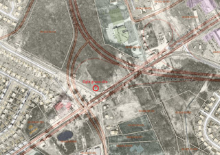
Thomas Ogle's restored gravesite commemorates the Ogletown area and the Ogle family influence, but is poorly maintained with no visible emphasis on history, place making and public access. Citing highway safety, no parking of any kind was installed from the SR4/Salem Church intersection. However, the East Coast Greenway (ECG) is a shared-use pathway (SUP) facility along SR4 that passes approx 50 yards' from the gravesite. The ECG connects to the Ogletown Baptist Church (OBC) via a 4' wide, 500' long asphalt sliver of what was formerly Red Mill Road. With no maintenance to speak of, mother nature (the elements) is reclaiming both of these facilities along with the gravesite. It should be noted that OBC greatly expanded its car parking lot since the idea of public access was last revisited in the 1990s. This lot is grossly underutilized except on Sunday mornings, and today serves as defacto gravesite car parking. Either the OBC or DelDOT needs to repave the 4' Red Mill asphalt out to 8' (according to MUTCD guidelines), and the ECG similarly repaved in an inviting manner that includes a spur pathway, bike parking and kiosk immediately adjacent to the gravesite.
Originally a cross-roads, farming and gathering community, Thomas Ogle and Ogle family generations have lived in the Area for over 250 years. A writer for the Wilmington News Journal in 1998 said it well: “Thomas Ogle’s grave is the last vestige of a town that was founded before the American Revolution and has been virtually under siege ever since”. Large office buildings, condos, apartments, sub-divisions, shopping centers, highways and streets have long since replaced the pastoral setting of Thomas’ days.
Statement of Significance:
Thomas Ogle, (born 1705 in DE, died 23 Dec. 1771 in New Castle Co., DE) was a grandson of the soldier/immigrant John Ogle, (born 1648/49 – died 1684) who came from England with the Richard Nicolls’ Expedition in 1664 and was possibly the first Ogle in the Americas. Thomas became a wealthy and influential businessman and planter in New Castle County, DE. His various businesses, large land holdings and community influence led to the sizable area around his home being named Ogle Town (later Ogletown) sometime before 1762. The stately house, which Thomas operated as an Inn, survived for 216 years. Thomas was buried near the historic house and a reasonable distance from the then narrow, dirt roads that formed the crossroad.
Thomas Ogle’s various businesses, large land holdings and community influence led to the sizable area around his home being named Ogle Town (later Ogletown) sometime before 1762. The stately house, which Thomas also operated as an Inn, survived for 216 years. Thomas was buried near the historic house and a reasonable distance from the then narrow dirt roads that formed the crossroads.
Respectfully Submitted by: Kenneth M. Ogle, President, Ogle/Ogles Family Association, Inc. Francis Warnock & Angela Connolly, OgletownResilience.org, 1stBikes.org
Above: Bicycling to Thomas Ogle's tomb in Spring of 2016. The site appears somewhat maintained as little as 5 years ago. Today, a quarter millennium since his death, it has nearly disappeared under tree overgrowth.
Greetings, Wilmapco. Please add our comments below to the Churchmans Crossing Plan, before the Sept 2021 deadline. Upon generations of failed elected leadership, and climate catastrophe now looming, the need to facilitate active and green transport modes could not be more dire. Thank you very much.
In no particular order:
The project scope contains several bi-directional MUP facilities (Multi-User Pathways) that were built decades ago. Along SR4 and SR58 is the East Coast Greenway (ECG). These need to be improved and/or rehabbed using best design & engineering guidance (APBP/NACTO compliance) esp where crossing through intersections.
Where MUP facilities exist, or will be added, these should never go off-alignment with acute zig-zagging through intersections via narrow sidewalks; MUPs should maintain their full width (min. 8' wide asphalt, buffered where possible) and continue in parallel to the road they are on, including through radial turns. Look to DelDOT's "SR299, SR1 to Catherine Street Project (pdf)" as a good example, or APBP/NACTO guidelines.
An 8' asphalt MUP facility should replace the narrow sidewalk on SR58/Churchmans Rd from just east of Christiana Hospital to at least Cavaliers, and include a marked, button actuated crosswalk (of equal width) under SR7/1. A MUP currently exists along the Christiana Hospital property, and there is a well designed bike-ped bridge over I95 further east on SR58 as you approach Cavaliers. These should all be connected in one contiguous 8' bi-directional facility, as an improvement to the ECG.
A park that includes ball courts, walking & biking paths, benches and other forms of place and destination-making is desperately needed for Harmony Woods and the region in general.
Add a shoulder bike lane on Salem Church Rd between I95 and Old Baltimore Pike, on what is technically "Bike Route 1". Cars and trucks cannot safely pass cyclists here without entering the opposing lane, and road rage commonly ensues.
Reduce the speed limit on SR4 from 50 mph to 40 mph, and 35 mph in school zones: DE Deaf-Blind, Kirk MS. Several speed studies over the years have shown rampant speeding along this corridor, in access of 57 avg mph. Investigate the use of traffic calming measures such as median vegetation plantings, signage, and other means to protect the children from these schools, as well as the surrounding neighborhoods. They often cross SR4 at Augusta, going to and from 7/11 for snacks. Reducing the speed limit cannot be emphasized enough. Delaware is now ranked #1 deadliest State in the nation for biking, and near #1 for walking, largely due to abject failure in this regard.
Recognize and honor the passing of Thomas Ogle, founder of Ogletown, who died exactly 250 years ago on 12/23/1771. This should include a spur pathway connector from the existing SR4 MUP aka ECG, along with a historical wayside and some bike parking (as seen at regular intervals along, e.g. the Markell Trail/Indus Track). This article in Delaware on-line from 2015 highlights that very need, which went ignored.
Typical "goat path" from the ECG in S. Newark
Reduce neighborhood street speed limits from 25 to 20 mph, led by a "20 is Plenty" safety campaign or similar. Cost estimate HERE.
Assess, formalize and convert all "goat path" connections into MUPs. These are commonly visible coming off existing MUPs, usually connecting to adjacent shopping centers and strip malls. These occur when numerous people walk or bike across grass that eventually erodes and forms its own trail. These should be upgraded to pathways.
Please advise how we may track our comments through the process, to verify if they are being considered for implementation or not. Thank you for listening.
Mother Nature closing in: Thomas Ogle's tomb as of Aug 3, 2021
Thomas Ogle, founder of Ogletown, will have passed away 250 years ago as of Dec 23, 2021. Unless something secret is planned that we don't know about, this historical moment in time -- a quarter-millennium ago -- may come and go with nary a peep from regional State and NCC Legislators. According to a reliable source familiar with historical preservation and legislation in Delaware:
Asking your State legislators for a proclamation from the General Assembly is a good place to start. The legislature won't be back in session now until January but a staff person can help draft one during the summer months, and in the opening days of legislative session read it and present it to your group.
Next step: It takes a while to get funding from the State as they have just completed this fiscal year and won't have access to money until next June, but this is the right time to plant the seed. It may take as long as 2 or 3 years as the legislators will have to negotiate with Parks & Rec and DelDOT, but the more clearly you can write a one page proposal of who, what, when and where (about 100 words) and get it to appropriate staff people in those agencies, with cc's to your elected officials, the better luck you will have.
Though most of this doesn't sound very difficult per se, involvement from our end will be difficult to stomach. 3 years of our lives were lost, discarded, thrown away by the region's legislators in our attempt to save the Orphanage Property, which was crushed under the boot of DE government corruption that included conspiracy, profiteering and a rampant conflict of interest.
Thomas Ogle (born 1705 in DE, died on Dec 23 1771 in New Castle County (NCC), DE, possibly married three times and with nine known children), was the son of Thomas Ogle (born 1666/72 in DE, died between Juuly 30 and Sept 18 1734 also in NCC, DE) and Mary Crawford. He was the grandson of the immigrant John Ogle (born 1648/49 — died 1684) and Elizabeth, whose maiden name has not been irrefutably identified.
Thomas became a wealthy and influential businessman and planter in New Castle County. He owned three mills and a wharf at Christiana Bridge, hundreds of acres of agricultural and forested land in NCC, and many additional investments.
Thomas built a stylish, two-story, brick house in 1739 at the northeast corner of a junction of three important roads: present day DE SR273, which extended from Christiana Bridge to Nottingham in PA; DE SR4 4 (Chestnut Hill Rd.) from Stanton through Newark DE to the Elk River in Maryland; and Red Mill Road, which ran north from the intersection of SR273 and SR4 to Corner Ketch. All these roads were significant transportation arteries by 1750 and have remained important for 250 years. A fourth highway, Salem Church Road, was constructed in 1827 in a southerly direction from the intersection.
Thomas Ogle's various businesses, large land holdings, and community influence led to the sizable area around his home being named Ogle Town (later Ogletown) sometime before 1762. The stately house, which Thomas also operated as an inn, survived for 216 years. Thomas was buried near the historic house and a reasonable distance from the then narrow, dirt roads that formed the crossroads.
Sadly, it is doubtful that Senators Bryan Townsend and Jack Walsh, Reps Osienski and David Bentz, or NCC's Lisa Diller and Tim Sheldon (all of whom represent Ogletown) will recognize anything about Thomas Ogle and this historical milestone. No park or monument designation, no spur pathway, no kiosk, not even a wayside. And why should they care? The region is socio-economically depressed and undeserving of nice things that include history and place-making. As demonstrated by the STOP travesty, citizen advocacy would likely falter (or even be laughed at) in the face of low to no public or volunteer support.
Around the anniversary date of Dec 23, we will visit the burial site with landscaping tools of our own, and leave a tribute behind to remind Thomas that someone was indeed thinking of him (UPDATE 08/17/2021: we received an email from Delaware Public Archives (DPA) with regard to the Delaware Historical Markers Program. They are supportive of a Historical Marker installed at the site, which can only happen via an application process. Stay tuned for any progress.
There is only 1 park bench/rest stop along the paved Tri-Valley SUP
(Shared Use Pthway). There needs to be more, at equal distances, so
people can stop, rest and take in the views. The same goes for the entire length of the Pomeroy Trail.
"Shared Zone" (or similar, MUTCD) and posted speed limit signs need to be added along Creek
Road and Wedgewood Roads where these are paved and shared with motor
vehicles. See attached image (right). Presently there is no signage, and no posted speed limit, and cars --
often times speeding -- are weaving between bike-ped traffic.
We do NOT agree with the others who are against using stone dust,
fine gravel or limestone or other packing materials on trails. Please
continue to use these as a proven means to control erosion and formalize
trails as needed.
Please REMOVE the hanging cable that is blocking Tom Sharpe Lane, at Judge Morris Estate, turning in from Polly Drummond Road. This is a trip or
crash hazard, and should be replaced with a removable bollard(s) or
partial gate with clear bike-ped access, e.g. along Creek Rd.
Tell DelDOT to replace the unsightly concrete barriers on Creek Road
at the Pomeroy Trail bridge curve with something more aesthetically
pleasing. These are an eyesore and detract from the park's otherwise
beautiful scenery.
With the advent of "Gravel" bikes and wider trail riding, park trails
and pathways should be sub-grouped into the following categories, and
mapped as such, e.g. 1. PAVED 2. GRAVEL 3. MTB
The Tri-Valley SUP is very overgrown between 9 foot Rd and its
southern terminus at Thompson Station/SR72, and is reduced to about 2/3
width. This is hazardous for bi-directional bike-ped traffic. Please
perform maintenance, including mowing and edging. At 8', this is the min
recommended width for such a facility according to FHWA.
Improve safety for the bike-ped crossing between Creek Rd (gravel
section) and Tweeds Mill (nature center). A large-sized MUTCD-approved
R1-5 in each direction would be a big improvement. As it stands now,
most motorists continue through the marked crosswalk, even with people
standing there waiting.
Connect via SUP the Carpenter Area with the Pomeroy Trail, and that
with the Possum Hill and Middle Run Areas.
Continue working on a WCCSP-Fair Hill connection via SUP, if that is
still being considered.
Thank you so much for listening. Please let us know if there is a way to
track our comments, to verify whether or not they are being considered.
--Frank Warnock & Angela Connolly
Above: A hanging cable blocks the entrance to Judge Morris Estate at White Clay Creek State Park. Bollard(s) should always be used where foot & pedal traffic is permitted. Users -- especially the disabled -- should not have to lift their bikes, step over, or cycle around a lengthy stone wall to access the Estate.
Cross-posted from Bryan-Townsend.com. Read the full series here.
This post was featured on Bike Delaware's Facebook page on April 11. It's pretty self-explanatory, in terms of what regions of New Castle County receive priority based on socio-economic status. Surely, Rep Osienski will head over there again, outside his District 24, to help cut the ribbon with Baumbach (Rep, 24th) when completed. Bike Delaware is a developer's wildest dream, in terms of a corrupt org that drives advocacy only for the privileged few; forget the 'unwashed' -- or those living in the vast suburbs that include Ogletown-S. Newark.
Time and time again, Delaware fails miserably when it comes to leadership and quality of life. Here is yet another measure reaching the top 5: Noise. This study only crunched some numbers, and cited statistics, but it failed to include other factors such as law enforcement (level of, lack thereof). It didn't include the colossal failure by the State and its various Police agencies to penalize and/or prosecute for drag racing and modified vehicle exhaust systems. These include "fart can mufflers", straight pipes or other modified systems that vastly increases vehicle noise. For most residents living in New Castle County's suburbs, for example, even a half mile from the nearest arterial road can sound like track-side at a NASCAR event. Many people hear it inside their homes, even above their TV, especially on weekend nights. There is no police enforcement of this crime, so the offenders know they can get away with it. Often times, the decibel on acceleration is 120+ decibels, which if you're a pedestrian or bicyclist, is hurtful or damaging to the ear. This is assault, and 100% illegal according to Delaware law, in multiple code sections (HERE & HERE). Yet, as expected, it gets a free pass by Townsend and cohorts.
Where is Senator Townsend on this? Nowhere, that's where. He would rather pass a bill to criminalize snow on car rooftops, that may happen a few times each Winter. On the other hand, oppressive and painful vehicle noise from non-standard illegal exhaust systems goes FAR further in destroying the qualify of life, health and wellbeing of everyday Delawareans. Why doesn't Townsend and his Democrat-controlled legislature introduce a bill to step up prosecution of this deliberate and disgusting act by a small minority that hurts the clear majority, AND wildlife? Even the City of Newark and University Police won't enforce deafening vehicle noise, in an environment rich with walking and bicycling on or near the roads.
Senator Townsend, along with Rep Edward Osienski and NCC's Lisa Diller are the epitome of failed leadership. Not just in Delaware, but any State. Until we rise up and hold them accountable on issues like this, there will be no end to the corruption, in sight. Delaware is represented by the 4th most criminal State govt in the nation. Its residents have to act and vote with this in mind, in order to stop them.
Vehicle noise assault on a "complete street" in New Castle County, Delaware.
“If anyone walking along the sidewalk were to make deafening noises, spew poisonous gas into innocent faces, and threaten people with a deadly weapon, they would be arrested. Yet a few feet away, on the public roadway, it is considered normal behavior” ~Steve Stollman
The following email was sent to Senator Jack Walsh, Delaware District 9 (cross-posted from 1st State Bikes)
Greetings, Senator Walsh,
What is your plan for 2021, to repair and maintain what few asphalt
pathways are in your region? These serve as vital connectors for
foot/pedal traffic. As of right now, and last year, they are an
unmitigated disaster. We have attached a few pics in this email that you
should recognize, but there are plenty of others.
There is Bike Delaware, Delaware Greenways, DelDOT's Complete Streets, Gov
Markel's Trails & Pathways initiative, Gov Minner's Livable DE, Safe Routes
to School, etc etc we could go on and on. These pathways should be
clearly defined, with min. 8' wide smooth asphalt.
Rep Baumbach is busy cutting ribbons on parks and pathways projects in his
district all the time, in Newark. But yours -- like [Senator] Townsend's -- is
like a 3rd world country, at best.
What are you going to do about it? -- Frank Warnock & Angela Connolly
Above: An overgrown hedgerow and a 2" raised steel plate are the ultimate crash hazard along Wyoming Road. Yet this is routinely used as an extension of Newark's Hall Trail.
Above: Abandoned pathway along Wyoming Road in Newark. What was once wide and appealing for multi-modal use is avoided in favor of the road shoulder.
Above: What remains of a pathway spur connector, between Prides Crossing and East Coast Greenway along SR4.
Above: Brookbend "Park". Viable parks, pathways and placemaking are virtually non-existent in Walsh's District 9, and (Senator) Townsend's District 11.
Above: Bike Path, aka East Coast Greenway, parallel to SR 4, also in Walsh's District 9. Walsh could ask DelDOT to rehab this facility, and others, perhaps attached to local road rehab projects.
Walsh's reply as of 4/14/2021: I had previously answered your question on one of these paths. It is
located on private property and the Church is required to clean up the
path. This is the first I am hearing about the other two paths. One path
pictured is the county's responsibility, so
I can reach out to Councilman Sheldon's office about that one. The
other path is on Route 4 and I will contact DelDOT to get them to clean
that up.
No, Walsh did not answer anything, not in writing. We can find nothing in writing, and requested that he forward any sent emails that may have been overlooked. "3rd World Country" as defining Walsh's District 9 (and Townsend's District 11) for pathways, parks and destination/place-making is 100% accurate. It may even be an understatement. Will he answer our inquiry above, with a serious action plan? That remains to be seen.